Geo Tag Your Photos
Have you ever looked at one of your photos and wished you could remember where it was taken? Maybe you wanted to revisit a location to reshoot a scene but can’t remember exactly where it was or maybe you just want to share the location with others. Sure, you can manually geotag photos one by one when you get home and download everything, and if you only care about tagging a general location then that could work for you. But, if you covered a large area or just want a more specific location to geotag, you have a lot of manual work ahead of you.
Some cameras have a GPS module built in and for others you can purchase an external GPS module to tag photos as you take them. This is a fine option, and the easiest, but keep in mind that a camera powered GPS system will use your cameras battery. If you find yourself running low on battery power often, this is probably not the best option for you. You also have to consider the cost, around $200, of the external GPS unit if you don’t have a camera with one built in.
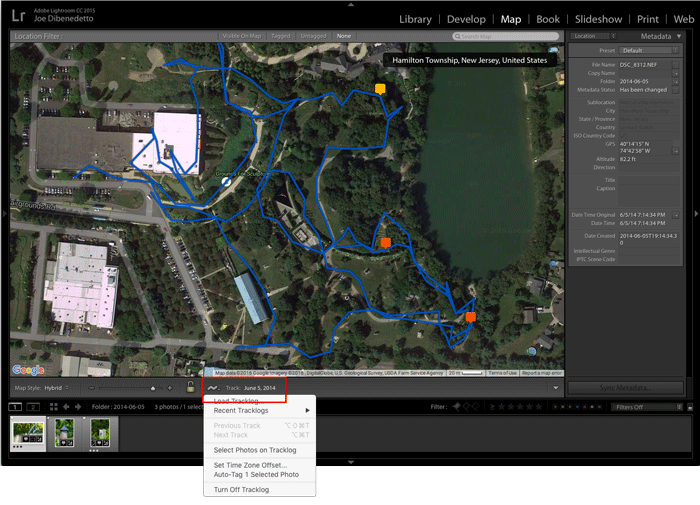
There’s a cheaper or even free option that doesn’t require you to buy any new hardware, unless you don’t own a smartphone, then you need to buy new hardware, you need to buy a smartphone. You simply download a Geotagging app for your smartphone, such as “Geotag Photos”. When you run the app, it will log your position every few seconds using your phones GPS and battery. If you have problems getting your phone through a normal day on a single charge you can tweek some app settings. Most of these apps will allow you to set how often your location is tagged, from every couple of seconds to every few minutes, reducing the strain on your battery. Just keep in mind that the longer the interval, the less accurate your tagging will be. You just need to, and I can’t stress how important this part is, synchronize the time on your phone and camera before starting. Try to sync the time down to the second and verify that the times are still in sync every time you use the app. When you're done shooting, you simply import your photos into Lightroom as you normally would. Next, you’ll need to save the geotag log from your phone to a location that Lightroom can access. You can email it to yourself or save it to Drop Box or similar service. Now, open the Map module in Lightroom and select the “tracklog” icon ![]() at the bottom and choose the option to upload the tracklog. Lightroom will then look at the time stamp of each photo and compare it to the tracklog to find the exact location you were standing at the time each photo was taken and add that location to the meta data on all of your photos. That’s it. All of your photos are now geotagged and in just a few clicks.
at the bottom and choose the option to upload the tracklog. Lightroom will then look at the time stamp of each photo and compare it to the tracklog to find the exact location you were standing at the time each photo was taken and add that location to the meta data on all of your photos. That’s it. All of your photos are now geotagged and in just a few clicks.